
America is home to countless back roads, side roads, and country roads… scenic routes, historic routes, and tourist routes… National Byways and Historic Highways…. and more road trip possibilities than any one person could complete in a lifetime. Hosting Take Back Roads since 2013 has inspired me to explore a great deal of back roads on local, regional, and long distance road trips…. including nearly a dozen cross country road trips!
In that time, I’ve learned one major fact about exploring back roads: the more of them that I experience, the deeper my appreciation becomes for just how many more there are to see!
This train of thought led me to develop the collaboration idea you see here. Since it would be impossible to take every back road in America, I recruited help: travel bloggers from all across the country. I reached out with a simple request: Please write about your favorite back road in the state of your choice. What do you like about it, what is there to see and do, and what makes it your favorite? I also requested one or two photos and the names and websites of any restaurants, shops, or local businesses they wanted to highlight (if applicable).
What should you pack for a road trip?
I also love headlamps since your hands remain free
Blanket or other way to keep warm
Disclosure: This post contains affiliate links. This means that I receive a commission – at no cost to you – if you purchase any of the products I’ve linked to on this page.
I also earn commission on any additional products you buy during that shopping/browsing experience, so if you want to keep TBR up and running, please shop with reckless abandon!

States are split between East and West of the Mississippi River, and then organized alphabetically. There are links to navigate the post. As you will see, while a couple states have two submissions and a few states have no submission yet, the vast majority have a single submission.
Feeling overwhelmed? We can help plan your next road trip.
Click here.

Looking for a great playlist to listen to while ON your road trip? Start here.
We are still missing THREE states: Indiana, Missouri, and Rhode Island. If you can provide us a back road in any of those states, please email me!
Our Second Installment in the Great American Road Trip Series can now be found HERE!
The Best Back Road by State: East of the Mississippi
Skip to Eastern States by first letter:
Skip down to the Western States
Alabama
AL-25 from Harpersville to Payne Lake

For a modifiable map, click here
State Route 25 from Harpersville, AL goes through the rural towns of Wilsonville and Columbiana. There is a” bed and breakfast” in Columbiana called the Columbiana Inn. The road continues to wind through beautiful farmland and vineyards. “Wine Trail” signs off SR-25 indicate the vineyard locations. Heart of Dixie Railroad museum in Calera is a great place for those who love trains! Calera also has a colonial American village recreation, “American Village”. There are a few parks along SR- 25 where the Cahaba River can be accessed. One of them is Shoal Creek Park. The town of Montevallo is historic and charming, and is home to the University of Montevallo. Continuing to meander down SR-25 passes through the small town of Wilton. You’ll soon find another significant historical site, Briarfield Iron Works State Park, which shows some of Alabama’s former iron production facilities. There is also a campground at this park. The Cahaba River National Wildlife Refuge is not far away, but down another back road. It is famous as a place to see and wade in the Cahaba River. State Route 25 continues to meander through beautiful rural Alabama and ends near Centerville, a nostalgic small town.
Betsey Hallmark, Shutterstock
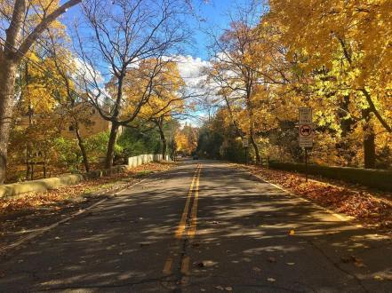
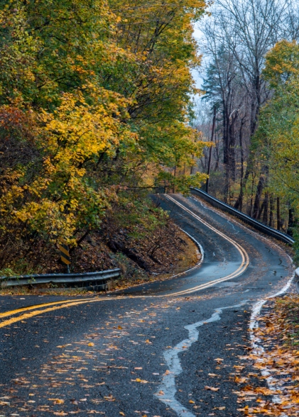
Connecticut
CT-39 & US Route 202 from the New York border to Granby

For a modifiable map, click here
Ironically enough, this submission is my own, and it’s technically comprised of four different back roads: CT-39 into Sherman, CT-37 and US Rt 7 into New Milford, and US 202 the rest of the way. I took this trip in February of 2018 while on my way to visit friends in Granby. Winter is not the ideal time of year for this drive. However, the rolling and winding route was still breathtaking enough to cause me to stop several times along its 70 miles to take pictures. Passing (and crossing) several beautiful lakes, two meandering rivers, and a handful of state parks, the scenic route also slices through the heart of traditional and historical New England farmland, villages, and towns. Though I noticed several enticing restaurants and wineries, time constraints prevented me from stopping to eat and drink.
Scott Berney, Take Back Roads

CT-169, Norwich-Worcester Turnpike
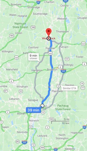
For a modifiable map, click here
State Route 169 in Connecticut is nothing if not bucolic. You’ll feel like you should be traveling by horse-drawn cart through the rolling hills past munching cows, orchards, fields, 19-century mills and colonial villages. The second-longest scenic route in the state (after the also wonderful Merritt Parkway, Route 15) runs from Lisbon to Woodstock on the state border to Massachusetts and carries the federal designation of National Scenic Byway. Stop at roadside stands for apple cider and pumpkins, go antique-ing, or enjoy some fabulous examples of historic architectural styles (e.g. Federal style in Canterbury).
Olivia, Happy in the Hollow

Delaware
Big Stone Beach Road

For a modifiable map, click here
This 8 mile long back road will show you the best of Delaware’s wetlands, and take you to a hidden gem of a beach on the Delaware bayshore. The road winds through a rural area of central Delaware, but as you drive, you can see the landscape changing with every mile. The suburbs transition to forests, then the trees open up to reveal an impressive expanse of salt marsh before the road finally dead ends at its namesake, Big Stone Beach. The beach itself offers stunning views of the dune and marsh habitat, and at low tide, you can see reefs and tide pools created by sand building worms. This back road is one that many Delaware locals have never seen, but it’s one that you won’t want to miss!
Abby Shepard, Abby Shepard Photography & DE State Parks
Looking for more Delaware content? Click here
Florida
Florida A1A Scenic and Historic Coastal Byway

For a modifiable map, click here
When you visit northeast Florida, my advice is to get off the interstate and take the back roads to explore. Specifically, the Florida A1A Scenic and Historic Coastal Byway.
This portion of Florida A1A stretches 72 miles from Ponte Vedra Beach (south of Jacksonville) past St Augustine and down to Flagler Beach. Due to the location of Hwy A1A between the Atlantic Ocean and the Intracoastal Waterway, the opportunities for fishing, birding, and beachcombing are abundant. In addition, there are historical sites along this stretch of road. Staying in St Augustine for a month allowed me to enjoy the beach life and learn about the history of the area, in particular the Castillo de San Marcos. The fort, constructed from the local coquina stone from 1672 to 1695, is well worth a visit.
Some of my best times in Florida were spent driving up and down the A1A highway visiting all the beaches near St Augustine including the coquina stone beach near Marineland.
Susan Moore, Solo Trips and Tips

Georgia
Appalachian Foothills Parkway

For a modifiable map, click here
My love for this beautifully scenic highway may be biased, since it starts less than 25 miles north of my house. From there it winds through the southernmost section of the Appalachian Mountains, twisting and turning alongside many of North Georgia’s major highlights. You can drive through the Chattahoochee National Forest and the Blue Ridge Mountains, hike to see picturesque Amicalola Falls, and take in the stunning views from atop Brasstown Bald. It’s especially gorgeous in the spring, when the Azaleas start to bloom, and when the leaves start to change colors in autumn. And since it’s only 60 miles long, it makes for an exceptional day trip from Atlanta.
Bret Love & Mary Gabbett, Green Global Travel

Illinois
Keslinger Road to Whiskey Acres, Dekalb IL
If you’re lucky and know where to turn, you can find yourself on Keslinger Road in DeKalb, Illinois, about 60 miles west of Chicago. Down a pin-straight road and nestled among corn fields, you’ll find Whiskey Acres, the estate distillery run by 5th generation farmers highlighted in the video above. Sure, there are back roads with rolling hills or more interesting vistas, but the warmth and sincerity of the family at Whiskey Acres is what keeps me going back. I don’t know another spot where I can visit 2-3 times a year and get hugs and cheers as I walk in the tasting room. A back road and a glass of whiskey – it doesn’t get better!
Savithri Grant, A Whiskey Mama
Kentucky
KY Route 80, from Watergap to Arlington

For a modifiable map, click here
Editor’s Note – for this map to work properly, when you open it, you might need to go to “Options” and click “Avoid Highways” – then it will follow KY-80 the whole way
The longest state route in the Blue Grass State, Route 80, clocks in at 425 miles. It sticks in the memory from our 21 states we’ve road-tripped across thus far. Route 80 offers so much to see. Near Somerset is Lake Cumberland, one of the largest man-made lakes in the world at 101 miles long. The Mammoth Cave National Park, with the world’s longest known cave system (400 miles), is a great excursion near Bowling Green.
Our most precious memory of this trip, though, is stopping to admire beautiful Belgian draught horses in the town of Fancy Farm, just outside Mayfield. The owner, Stephanie, came out to say ‘hello’ and told us all about her horses and life in Fancy Farm. It proved once again, it’s always people who make the place.
Darrin Henry, What the Saints Did Next
Looking for more Kentucky content? Click here
Maine
Old Canada Road Scenic Byway
Finding the best back road in Maine is a bit tricky—mostly because there are hardly any actual interstates in Maine, and back roads are as plentiful as lobster. While coastal road trips make most “best of” lists, I prefer the wild and remote roads of western Maine.
The Old Canada Road Scenic Byway is a 60 mile section of Route 201 stretching from the Canadian border to Solon, Maine. Despite its recognition as one of the most scenic roads in the country, you won’t find the kind of bumper-to-bumper traffic that descends upon the Maine coast in the summer—unless, of course, everyone is stopping for a moose.
In addition to reading tales of Benedict Arnold and lumber barons on historic markers, there are plenty of scenic rest areas as you travel along the Kennebec River. Plus a few quirky stops, like a retaining wall covered in birdhouses and the surprising interior of a historic meeting house.
Naomi Figueroa, Roaming the Americas
Maryland
Blue Crab Scenic Byway
You can take I-95 to get from one city in Maryland to another, but where’s the fun in doing that? If you are coming from Princess Anne, MD and want to go to Ocean City, one good option is to make your way to the Blue Crab Scenic Byway.
If you love water scenery, Blue Crab Scenic Byway is for you. Water lovers will be delighted on this trip with so many places to access both the Atlantic Ocean and the Chesapeake Bay. One can stop for lunch in the Crab Capital of the World (i.e. Crisfield), then take the ferry from Crisfield to the bay on Smith Island.
Don’t forget the famous MD Blue Crabs. Stop by Red Roost in Quantico, MD for some eastern shore eating. It’s open seasonally for all you can eat crabs (yum!), shrimp, fried chicken, and snow crabs. This restaurant also serves BBQ, steaks, and draft beer. If you are into crabs and the good old beer and BBQ, this is the spot for you.
Once you are in Ocean City, make sure to take photos of and on the boardwalk. Also, don’t forget to treat yourselves by going for the amusement rides found in Ocean City.
Allan Liwanag, The Practical Saver
Looking for more Maryland content? Click here
Massachusetts
Battle Road Scenic Byway
The Battle Road Scenic Byway pairs year-round beautiful scenery with a big dose of history. Running parallel to route 2A through Arlington, Lexington, Lincoln and Concord for 14 miles, it roughly follows the path of the British on April 19, 1775 at the start of the American Revolutionary War. You can stop at many culturally and historically important sites, such as the Minute Man National Historical Park, art museums, abolitionist sites, and the homes of Louisa May Alcott, Ralph Waldo Emerson, Nathaniel Hawthorne, and Henry David Thoreau.
Olivia, Happy in the Hollow
Michigan
M-22, Lake Michigan Circle Tour
Notable as one of the most scenic Pure Michigan Byways, M-22 is located in the “pinkie finger” of Michigan’s distinctive mitten. Originating in Traverse City and following the Lake Michigan shoreline in Leelanau, Benzie, and Manistee Counties, M-22 is a two-lane, hilly highway that twists and turns through historic villages and towns. It also crosses the Sleeping Bear Dunes National Lakeshore and the reservation of the Grand Traverse Band of Chippewa and Ottawa Indians in Peshawbestown. The road dates back to the original trunkline system established in Michigan in 1919, but most likely follows settler and indigenous pathways that are centuries older.
As part of the Lake Michigan Circle Tour, the road has developed a cult-like status among regional visitors and residents. It was made even more popular when designated “best scenic autumn drive” in the nation by USAToday in 2015. M-22 sign and marker theft has become a problem for the Michigan Department of Transportation, which has to replace more than 30 signs a year.
Fun things to do along your drive: plan a stop along Sleeping Bear Dunes’ 35 mile stretch of coastline, which won Good Morning America’s “most beautiful place in America” designation in 2011. Explore the Port Oneida Rural Historic District, consisting of 16 government protected farms settled by Europeans in the 19th century, and the historic village of Glen Haven, a lumber company town dating from 1865. Stop in picturesque Leland, on the site of one of the oldest Ottawa Native American villages, where a natural fish ladder made for good angling. Leland’s Fishtown historic area is great for shopping and lunching. Check out the historic Northport Lighthouse and the charming village of Sutt
ons Bay on your way back around to Traverse City. Along the way, stop in one of the numerous vineyards for a taste of local wine, or indulge in preserves and pies made with the area’s famous sweet cherry crop.
Betsy Wuebker, PassingThru
Mississippi
Natchez Trace, Nashville TN to Natchez Historical Park MS
The Natchez Trace isn’t your average scenic route: because of its natural beauty and historic value, it’s run by the National Park Service! The Natchez Trace is a meandering parkway that runs just over 400 miles from Natchez, Mississippi to Nashville, Tennessee. Many of the people who complete the journey do so on bicycles or motorcycles, but, of course, it’s a great drive for motorists as well.
If you enjoy hiking, the Natchez Trace offers sixty-five miles of scenic trails, some that can be used for horseback riding. Autumn is a great season to drive The Trace as the fall colors are present in all their glory.
Be sure to visit the National Park Service website for updated information on The Trace, including maps, accessibility, and history. From abandoned towns and ruins to Native American sites, scenic trails to Confederate gravesites, the Natchez Trace is an enjoyable, educational road trip through the state of Mississippi.
Jennifer Campbell, Just Chasing Rabbits
New Hampshire
Kancamagus Highway, NH Route 112, Conway to Lincoln
One of New Hampshire’s best-loved back roads, the 36-mile Kancamagus Highway cuts through a mountainous region of the White Mountain National Forest in northern New Hampshire. Locals love it when you pronounce this famous scenic byway correctly, so the first thing you should know is that it’s “Kank-ah-mah-gus”. The road runs west to east from Lincoln to Conway, providing spectacular views of the surrounding White Mountains.
Driving the Kancamagus Highway is a bit like stepping back in time. There are no stores, gas stations, or lodging, but you will find six National Forest Service campgrounds, ranging in price from $20 to $25 per night. Fall is a beautiful time to drive the Kanc, as it is affectionately known. The winding road has been named one of the top fall foliage drives in America many times over.
Hiking trails, scenic picnic areas, waterfalls, and covered bridges are among the top attractions, with many scenic pull-offs that require you to decide at a moment’s notice if you want to explore further. Our favorite destinations from our recent trip were the Lincoln Woods Trail, the Hancock Overlook, Sabaday Falls, Rocky Gorge Scenic Area, and Albany Covered Bridge. One of the beautiful things about the Kancamagus Highway is that there’s always something new to discover.
Tara Schatz, Back Road Ramblers
New Jersey
US Route 46, Delaware Water Gap to Fort Lee
(Editor’s note: As is somewhat common, US-46 tracks alongside I-80 for much of the road trip, so I made the map as close to the route described as possible… but it’s not perfect)
New Jersey packs a lot into a small package. Truthfully, you can create many interesting one to two-hour road trips there. For example, you can follow the Delaware River on the west side of the state, or follow the coast line on the east side of the state. You can also explore a plethora of curious sites on the outskirts of Philadelphia or New York City. But if you only have the opportunity to take one New Jersey road trip, this is my recommendation. If you were to stay on Route 46 the entire time and made no stops the entire journey would only take a little over an hour… but where’s the fun in that?
Start at the Delaware water gap and find Route 46, “the shortest signed, non-spur U.S. Highway in the country.” Head east to Morristown and Jockey Hollow, where you can visit Washington’s headquarters during the Revolutionary War. While on Route 46 you’ll pass through a handful of charming New Jersey towns — the kind of places most outsiders assume don’t exist in the nation’s most densely populated state.
Stop in Paterson and check out the Great Falls to see a breathtaking 75 foot water fall that passes more water by volume (2 billion gallons a day!) than any other falls in the eastern United States (with the exception of Niagara). Before you leave the area, be sure to check out the ruins of Hinchliffe Stadium, a place the New York Black Yankees once called home. When back on the road, head over to Weehawken for spectacular views of the New York skyline, and to walk the hallowed ground where Alexander Hamilton once fought Aaron Burr in a duel. End your day by heading back to Route 46 and Fort Lee, NJ, where you can stop by Hiram’s for one of the best hot dogs in the country. Not only will you have traversed Route 46 in its entirety, but you’ll have a full belly, great memories, and a new appreciation for New Jersey, one of the smallest and most geographically diverse states in our union!
Tim Tobitsch, Franktuary and 50 Franks
New York
NY Route 73, Adirondack Mountains
Some of the best back roads in New York are upstate in the Adirondack Mountains. I’ve gotten to drive quite a few while living up here, but one of my personal favorites is New York State Route 73. NY-73 is less than 30 miles long, but what it lacks in distance it makes up for in views. The road is nestled in among some of the Adirondacks’ largest and most popular mountains, and along streams through charming little towns. The road ends in Lake Placid, home of the 1980 Winter Olympics. While you’re passing through, you can also stop for skiing in the winter, or hike an Adirondack High Peak.
Danielle, Wanderlust While Working
Looking for New York content? Click here

North Carolina
US Route 301
(Editor’s note: As with Kentucky, you will likely have to click on “Avoid Highways” to ensure that this route follows US-301 instead of I-95)
Running parallel to Interstate 95, choose HWY 301 to discover North Carolina. This historic route linked tobacco and cotton farms connecting small towns and rural communities. Today, tobacco farms have given way to modernization, but the quaint charm remains. Travel HWY 301 to discover southern cuisine like pulled pork and fried chicken. Grab a fresh squeezed orangeade at the local pharmacy counter. Take a break in Wilson to see Vollis Simpson’s famous whirligigs, or stretch your legs at the botanical gardens in Fayetteville. Wherever you go on HWY 301, discover authentic North Carolina: great food, unique shops and historic places.
Karen Dawkins, Family Travels on a Budget
(Editor’s Note: I was very tempted to write another submission for North Carolina about my favorite road in the state, US Route 21. However, I’ve written a full blog about our experience, both heading South, and also about heading back North. You can read more there!)
Looking for more North Carolina content? Click here

Ohio
Hocking Hills Scenic Byway – State Route 374
State Route 374 in southeastern Ohio is also known as the Hocking Hills Scenic Byway as it connects all six of the Hocking Hills State Park sites: Cantwell Cliffs, Rock House, Conkle’s Hollow, Old Man’s Cave, Cedar Falls and Ash Cave. The byway begins near Rockbridge at the intersection of US 33 and Route 374 and continues just over 26 miles to Ash Cave. While you can easily enjoy the route in a day from the comfort of your vehicle, the route is best explored when you allow time to explore the parks, hiking trails and remarkable scenery that comprise this unique destination. The route provides an opportunity for visitors to appreciate and enjoy the outdoors year-round. You’ll find plenty of lodging options from campgrounds to luxurious cabins along the route with places to grab a bite to eat.
Tonya Prater, Travel Inspired Living

Pennsylvania
PA Route 32, between New Hope & Kintersville
I’ve driven thousands of miles through Pennsylvania, but there’s no drive better in the state than PA Route 32 between New Hope and Kintersville. This road runs along the Delaware River on the eastern edge of the state and features fantastic views of the water. Opposite the river, steep cliffs give rise to many beautiful waterfalls (if you visit during times of high water).
Along the road are fantastic highlights like Ringing Rocks County Park, Delaware Canal State Park, and the charming town of New Hope. You’ll also be driving past homes, barns, covered bridges, and other structures that are centuries old.
This combination of natural beauty, historic charm, and a curvy road make this my favorite drive in Pennsylvania.
Jim Cheney, UncoveringPA and Tripologist
(Editor’s Note: the charming town of Lumberville is also on this route, which plays home to the absolutely marvelous 1740 House. Members of my family have stayed there for romantic getaways or relaxing long weekends since it first opened in the late 1960’s. If you explore this area, I highly recommend you stay here. Note – no kids under 14 are allowed!)
Looking for more Pennsylvania content? Click here
South Carolina
SC-174, Edisto Island
Plying the back roads — the back, back roads – of South Carolina inevitably will present you with a gift basket of surprises. Looming magnolia trees and Spanish moss. Tiny, rural communities populated with folks who more than likely will be happy to spend the afternoon beguiling you with the stories of their lives. Makeshift farm stands and BBQ pits that you can sniff out a mile away. Ramshackle houses and dilapidated plantations evoking chapters from another world.
One day I was riding along old State Road 174 north of Edisto Island and happened upon the Ernest F. Hollings ACE Basin National Wildlife Refuge. This sprawling natural gem encompasses more than 12,000 acres. But the day I discovered it, I met more alligators than people. A lovely antebellum former rice plantation sits on the property. Besides the alligators, I saw wood storks, egrets and ibises. Lazy streams and ancient paths wind through the refuge. And I had it all to myself.
Louis Berney, Freelance Journalist for the Washington Post and beat writer for the Baltimore Orioles
Looking for more South Carolina content? Click here
Tennessee
The Snake – US Route 421
Many people are most familiar with northeast Tennessee for its Smoky Mountains, but if you are looking for a challenging and beautiful Tennessee scenic drive, travel northeast of the Smokies to Hwy 421. This 112 mile Tennessee highway is a very popular stretch of mountain highway among sports car enthusiasts and motorcyclists. Within this 112 mile highway lies a 37 mile section known as “The Snake” and for good reason. This section of highway “snakes” its way through Sullivan and Johnson County, TN taking motorists up the mountain through 489 curves providing one of the most beautiful and thrilling scenic routes in northeast Tennessee. The “snake” isn’t for the weak of stomach, however, but it is fantastic for those who enjoy riding the switchbacks over the mountains while surrounded by beautiful countryside.
Amanda, VeraVise Outdoor Living
Looking for more Tennessee content? Click here
Vermont
VT Route 100, between Wilmington & Newport
Vermont is known for its mountainous back roads, incredible recreation opportunities, and charming New England villages. There are endless opportunities for road-tripping in Vermont, but route 100, which runs right through the center of the state, is probably the most iconic stretch of pavement. At 216.6 miles long, it is Vermont’s longest state highway, and it’s also one of the most beautiful. If you’re are looking for a quintessential Vermont road trip, then route 100 is the perfect place to start. It starts in the southern town of Wilmington and winds its way north through the Green Mountain National Forest to the Canadian border. Heading north, the road passes pristine mountain lakes, cascading waterfalls, quiet campgrounds, and secret swimming holes. This awesome Vermont road trip is best enjoyed in the summer or fall so you can take full advantage of the outdoor adventures available in the mountains.
Tara Schatz, Back Road Ramblers
For an in-depth look at things to do in Vermont, click here
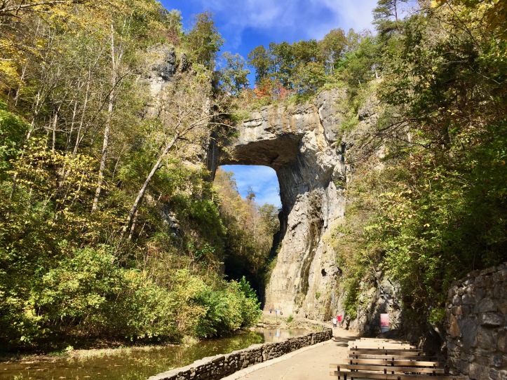
Virginia
Skyline Drive, Shenandoah National Park
Skyline Drive is a beautiful Virginia byway that goes straight through Shenandoah National Park and the picturesque Blue Ridge Mountains. It’s especially vibrant – and popular! – in the fall, when the leaves reach their peak colors. It’s not exactly a well-kept secret, but if you’re able to hit the road early enough to catch a misty sunrise, you might be able to beat some of the crowds and enjoy a colorful drive with slightly fewer cars. At just over 100 miles long, it makes for a great half-day drive. This DC local thinks it’s a must see!
Mary Beth, from MB Sees
Looking for more Virginia content? Click here

.jpg)
Historic US Route 11, Winchester to Wytheville
(Editor’s note: As is the case with many of the older US Routes (the white shield with a black border), Route 11 runs parallel to I-81, so mapping out the actual trip described is now essentially impossible. Google maps eliminated the feature to allow the embedding of full route adjustments, so when you open the map, choose “Avoid Highways.”)
Small towns dot historic Route 11 as it meanders north to south through the Shenandoah Valley in Virginia. The historic road evolved from Native American warrior path to a migration route known as the Great Wagon Road, before it became the Valley Turnpike in 1834. Wineries, apple orchards, farm stands, and local restaurants offer great places to relax and refresh along the route.
Begin your Route 11 road trip with a visit to the historic Winchester walking district, and a delicious meal at Sweet Nola’s. As you head south, stop at Route 11 Chips to sample the popular flavored chips and watch them being made. Further south, stop at Natural Bridge State Park, a 500-year-old rock formation that towers over a stream. Head into Lexington for a delicious fried chicken dinner at the Southern Inn. Finish your trip with a stay at the historic Hotel Roanoke where you can sample the city’s many museums and great restaurants like Local Roots in the funky Grandin neighborhood. Route 11 offers a fabulous mix of American history, nature, and small town fun.
Julie McCool, Fun in Fairfax VA
Looking for more Virginia content? Click here
West Virginia
US Routes 19 & 250, Morgantown to Monongahela National Forest
West Virginia’s motto is “Wild and Wonderful,” and truer words may never have been spoken about the state. Much of the state is completely undeveloped wilderness, which makes it a prime destination for excellent road trips – especially on a motorcycle. Countless back roads zig-zag up and down the mountains and meander through the dense forest lands, making it tough to pick just one – so I didn’t! And I enlisted a friend who just posted a rather unique video about his somewhat unusual traveling motivation – hot dogs!
Tim Tobitsch, owner of Franktuary here in Pittsburgh, described his destination in Clarksburg as “a town with some interesting history. Native Americans are known to have inhabited it since at least 1000 A.D. It played a significant role in the Civil War – and was the birthplace of Stonewall Jackson. In the first half of the 20th Century one of the nation’s largest manufacturers of glass called it home.” Tim’s review of his experience at The Ritzy Lunch are in the YouTube video below.
Branching further south and east of US Route 19, US-250 runs a looping route to and through the Monongahela National Forest towards the Virginia border. A historic spur of the iconic cross-country route US-50, US-250 cuts diagonally across West Virginia, northwest to southeast. Though the route cuts through several old coal mining towns with adorable Main Street style shopping districts, the real highlight is the sections between towns: cutting across farmlands, forests, and up sizeable ancient mountains.
This is a culinary wilderness adventure that’s not to be missed!
Scott Berney, Take Back Roads, and Tim Tobitsch, TheSausageSage
Looking for more West Virginia content? Click here
Wisconsin
WI Route 42, Egg Harbor to Gill’s Rock
Out of all of the scenic drives along Lake Michigan in Wisconsin, highway 42 in Door County is arguably the most beautiful. The stretch of the highway from Egg Harbor up to Gills Rock on the northern tip of the peninsula is loaded with breathtaking coastline, wonderful small towns with plentiful shopping, cherry orchards, and vineyards. During the wintertime, Green Bay becomes an ice fisherman’s paradise and the trails of Peninsula State park are alive with visitors snowshoeing and cross-country skiing.
However, this stretch along highway 42 in Door County is arguably at its most beautiful in the fall, when the leaves are changing colors. With the state forests full of color and beautiful Lake Michigan as a backdrop, it isn’t hard to see why people flock to Door County in the fall to enjoy the changing of the seasons.
Josh Hewitt, Wanderlust Travel & Photography
Feeling overwhelmed? We can help plan your next road trip.
Click here.
The Best Back Road by State: West of the Mississippi
Skip to Western States by first letter:
Alaska
Alaska Route 1, Homer to Anchorage to Tok
Anyone who hightails it up to Alaska will be driving at some time, probably most times, on Alaska Route 1. Almost 600 miles long, it’s the main route from anywhere to Anchorage, the largest city. Most drives are on the Seward and Sterling highways, because from Anchorage to Homer, fisherman come in droves hoping to catch the king of fish, salmon. The road is not that wide, but the scenery is stunning as you follow along Turnagain Arm, through the Kenai forest from Seward to Soldotna, then along the Cook Inlet to Homer. Along the way you will see all kinds of wildlife from an abundance of birds to the huge Alaskan moose.
Corinne Vail, The Roving Vails

Arkansas
Mount Magazine Scenic Byway, Ozark to Havana
The northwestern corner of Arkansas is home to some big players in the arena of natural beauty, including the Ouachita National Forest and the Ozark National Forest. But it is the region in between these two that endeared itself to me in its humble beauty. Between these two forests traverses my favorite Arkansas back road, the Mount Magazine Scenic Byway.
Mount Magazine Scenic Byway, also known as Highway 309, runs roughly north to south from Ozark to Havana. Along its span, this road winds through a collection of quintessential small towns and lazy farmlands. The highlight of this back road, however, has to be its passage through Mount Magazine State Park, home of the highest point in Arkansas. Approaching the park, visitors will find themselves steadily increasing in elevation, lending to some stunning roadside views over the expanses below.
Other notable stops along the Byway include Cove Lake Recreation Area, a great option for hiking, sightseeing, water sports, or a quick picnic! The best place to stop and eat along the route is Cove Creek Supply, a local spot known for their awesome burgers and other classic American foods.
Kristen Czudak, Yonderlust Ramblings
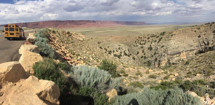
Arizona
AZ-67 & US-89, North Rim of the Grand Canyon to Flagstaff
Though only about 50 miles as the crow flies, the drive from the North Rim of the Grand Canyon to Flagstaff (or vice versa) requires over 200 miles and nearly four hours…. but what a breathtaking drive it is! I had a difficult time choosing between this drive and AZ Route 64, which runs parallel to the South Rim of the Grand Canyon, but the diversity of the scenery and the sweeping panoramas along this drive helped it to win out.
Starting in the lush woodlands and grassy plateaus of the North Rim section of the park, the first leg of the road trip features a nice assortment of green landscapes, and if you’re lucky, a herd of bison. Shortly after making the right onto US-89A, however, the surroundings begin to change rapidly as you drop in altitude down to the desert floor. Make sure to stop and walk across the Navajo Bridge at Marble Canyon for some pretty breathtaking views. The 125 miles from Marble Canyon to Flagstaff crosses a broad expanse of the starkly beautiful Arizona desert with very few pitstops – so make sure you have a full tank of gas!
Scott, Take Back Roads
Looking for more Arizona content? Click here
California
CA Route 12, Sebastopol to San Andreas
California’s State Route 12 (known as Highway 12 by the locals) is a 140 mile road trip that runs east-west from Sebastopol (in Sonoma County) to San Andreas (in Calaveras County). The most beautiful part of the highway is arguably the stretch between Santa Rosa (near the Melita Road Intersection) through Sonoma, where the highway is lined with stunning vineyards and redwood trees. During your drive you will pass by numerous wineries with varying tasting room hours. Ledson Winery in Kenwood, a personal favorite, is known as Sonoma County’s Wine Castle. Its gothic architecture and spires are stunning against Sonoma Valley’s mountain backdrop. Originally built as a private residence, it catches the attention of all drivers and deserves a visit.
(Editor’s Note: Leah will be submitting photos for this route soon. In the interim, if you’re a follower of my blog, you know that I have a TON of California photos to peruse….)
Leah, An Adventure is Calling
Looking for more California content? Click here
Colorado
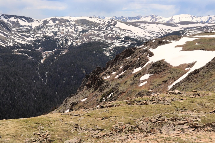
Trail Ridge Road, US-34, Grand Lake to Estes NP
(Editor’s note – since Trail Ridge Road is closed in winter, Google Maps won’t allow me to create a map of the road trip described below. Instead, I’m including a map of a location on the route so you can see where it is, and I will be updating the post with a proper map this summer!)
A highway to the sky, Trail Ridge Road is the 48 mile portion of U.S. 34 between Estes Park and Grand Lake, Colorado. To me, this is one of the most beautiful stretches of road and mountains you will ever see.
In just a few minutes you travel up from Estes Park and the temperature drops 20-30 degrees. The awesome tree-covered landscape changes to tundra as you climb higher and higher. At the top point, 12,183 feet in elevation, the wind whips and even in summer cars drive by walls of snow.
Not only are there views of majestic mountains, valleys, and snakelike rivers, but you’ll also find a variety of wildlife and plants. You will see the pine trees, the flowers and grass of the tundra, and so much more I can’t begin to identify. Personally, when traveling the road I’ve seen moose, elk, deer, coyotes, bighorn sheep, marmots, chipmunks, and all sorts of birds.
If you’re nearby, make a day trip out of it. Take your time and get out of the car to enjoy the scenic views or take one of the short hikes. The Alpine Visitors Center is almost at the top on the Grand Lake side and worth a stop if nothing else but for the photo op.
One of my favorite places on earth… don’t miss Trail Ridge Road.
Lauren Gonikishvili, Explorer Momma
Hawaii
Mamalahoa Kona Heritage Corridor, Hawaii Route 180
If you’re looking for a way around the Kona traffic, your best bet is Mamalahoa Kona Heritage Corridor. This 20 mile scenic byway is a section of Hawaii Route 180 that passes through the outskirts of the little town of Holualoa, which is known for its coffee and art.
In the old days, this route was part of a footpath encircling the Island of Hawaii. Now, it’s a narrow, two lane road that curves along the slope of Hualalai Mountain. The 30 mph ride takes you through old Hawaii with views of the ocean, beautiful foliage, historic architecture, cemeteries, and coffee farms.
Despite its reputation as an historic town, Holualoa is thriving with locals and tourists alike. Make sure you stop in town on the drive for a cup of Kona coffee, a bite to eat, and a chat with the friendly Holualoa School kids at recess.
Rachel Bergstrand, Roadtrips & Kittens
Idaho
Mountains, Valleys, and raging rivers: Horseshoe Bend to Sun Valley

For a modifiable map, click here
For a state that’s known for potatoes, Idaho is actually home to thousands and thousands of acres of jaw-dropping mountain peaks and rugged high elevation forests, densely packed with evergreen trees. Raging river rapids carve deep valleys between these towering mounds of granite, and some poor DOT engineers had to figure out ways to squeeze useable roads in there somewhere.
It’s not all narrow rugged wilderness, but even the more refined parts of this drive are absolutely beautiful. I had a really hard time deciding which part of this drive to highlight for this write up… so I went with all of it. Starting and ending in two entirely different outdoor recreation towns – Horseshoe Bend and Ketchum, respectively – this route will weave and twist you along valleys of varying widths, running parallel with the Payette River all the way up to its headwaters about 15 miles east of Lowman. It starts and ends in broad, sweeping valleys surrounding by rolling mountain peaks, bookending a narrow valley winding between steep-walled mountains.
There are more vista points to stop and soak it all in than I could even begin to highlight… but if you take it slowly and give yourself plenty of time to absorb the natural scenery surrounding you, you’re going to fall head over heels in love with Idaho, just like I did.
Scott Berney, Take Back Roads
Iowa
Loess Hills National Scenic Byway
(Google Maps occasionally makes building these backroad maps for you into a challenging exercise. When the route in question runs near a major interstate, it’s next to impossible to get the correct backroads route to display. If you want to see the full looping route for the Loess Hills National Scenic Byway in Iowa, please click here.)
In a state that’s perhaps best known for the intersection of Interstate Highways, it’s fun to explore some of North America’s earliest crosscountry trails. Few people consider the beauty of western Iowa, where the layers of hills roll right out of a Grant Wood painting away toward the bluffs overlooking the Missouri River.
Along Iowa’s western border, travelers can explore the origins of several historic byways. The Lewis and Clark Monument, overlooking the Missouri River and Omaha, marks the occasion of the explorers’ 1804 meetings on these bluffs with local Indian tribes.
The Western Historic Trails Center in Council Bluffs describes the paths of the Oregon and California Trails, and tells the story of the Mormon encampments here along the Missouri when a particularly bad winter halted their western progress. The Union Pacific Railroad Museum offers exhibits about the transcontinental railway whose eastern terminus was established here by President Lincoln based on his visit in 1859.
To carve your own route through history, drive north from Hamburg to Council Bluffs along Loess Hills National Scenic Byway . Then head to Hitchcock Nature Center. Here the hills contain rare geological formations, remnants of pristine prairie, and opportunities for low-impact and highly scenic recreation. From there, continue to follow the Loess Hills Scenic Byway northwest, exploring as many of the various points of interest along the way as you desire!
By Kristin Henning, TravelPast50.com
(images belong to Loess Hills Alliance)
Kansas
US Route 66, the “Mother Road,” Galena to the Oklahoma Border
“Taking the back roads” is more than just a phrase in Kansas. Here, it is a way to connect with the land. Why take the interstate when you could be rolling down a two-lane highway, cruising along a scenic route, or stirring up dust along an old dirt road?
Route 66 is a prime example of a great alternate route. Located in the southeast corner of the state, it is the smallest section of the Mother Road at a mere ten miles long. Don’t let that sway you from investigating, since it is filled with some unique sights along the way. Check it out once, and you’ll fall in love with back road travel.
Jeff Bryant, Our Changing Lives
Louisiana
LA State Route 31, Opelousas to New Iberia
LA-31 is a 54 mile north-south state highway in the Louisiana parishes of Iberia, St Landry, and St Martin. From LA-182 in Opelousas, Hwy-31 winds along the Bayou Teche, south to New Iberia.
During my multi-year road trip around the USA I’ve visited Louisiana four times. And each time I enjoy exploring another slice of Cajun Country. Starting out in Opelousas, take a moment to stop in Hebert’s Boudin and Cracklins and grab some road trip snacks. As the route winds along the Bayou Teche, you may want to pay tribute by taking a moment to visit Bayou Teche Brewing in St Arnaudville.
Continuing south to Breaux Bridge you can do a swamp tour or try kayaking with alligators at Lake Martin. In St Martinville be sure to visit the Evangeline Oak, named for the heroine in Longfellow’s epic poem, Evangeline. If you have more time you can also visit the Longfellow Evangeline Historic State Site.
Finishing up the road trip in New Iberia, you can grab a bite to eat at Victor’s Cafeteria or satisfy your sweet tooth at Meche’s Donuts.
Susan Moore, Solo Trips & Tips
Minnesota
MN Route 61, Duluth to Grand Portage State Park
Spectacular scenery and more along Minnesota’s North Shore
Minnesota has a lot of great road trips, but Highway 61 along the North Shore of Lake Superior should be on every traveler’s list. Start in tourist-friendly Duluth, but don’t stay too long – Minnesota’s best scenic drive begins once you leave town. Follow the shore of Lake Superior north to the Canadian border for a 150 miles of shimmering water, rocky beaches, towering cliffs, rushing waterfalls, forested hills, lighthouses, art galleries, historic sites, and fresh local food. Spring and summer bring wildflowers. Fall adds brilliantly colored leaves. Give yourself a couple days to do it all.
One of the best ways to explore Minnesota’s back roads and enjoy Minnesota at its very best is in an RV. Don’t have an RV? Why not rent one through RV Rental Minnesota – and spend a week or two affordably experiencing everything Minnesota has to offer!
Cindy Carlsson, Exploration Vacation
Montana
US Route 2, Idaho border to North Dakota border
Most people crossing Montana by car will take a combination of I-90 and I-94. An alternative is to take a meandering road trip on US Route 2 across the northern part of the state. US-2 goes from the hills near Idaho, across the Continental Divide near Glacier National Park, and finally across the high plains as you go from west to east. This mostly 2-lane highway will take you through many little villages – the largest city along this route has only a bit over 23,000 people. Although the cities along this route aren’t known for their tourist activities, there are some interesting and quirky sites to see. Favorites in the western half of the state include the Montana Vortex and Glacier National Park. Central Montana includes the underground city in Havre. Eastern Montana has the Glasgow metal animals and the Sleeping Buffalo Hot Springs.
Lisa, TheHotFlashPacker
Nebraska
Sandhills Scenic Byway, Grand Island to Hemingford
(Ed: I hope that Stephen King fans will appreciate my selection of endpoint for this road trip)
There is a reason that the 5 hour scenic drive on the Sandhills Scenic Byway in Nebraska (yes, Nebraska!) is one of the top 10 scenic drives in the US. You’ll go over rolling hills, through a national forest, can see the famous Sandhill Crane Migration, drive over one of the world’s largest aquifers and see plenty of wildlife along the way. You’ll feel a world away from all your stresses and marvel at the pure wilderness and seemingly untouched nature.
So, next time you are doing a cross-country road trip, instead of flying through the state of Nebraska on I-80 and just assuming that Nebraska is only boring, flat, and cornfields, get off the beaten path a little and see what the locals see and love about our state!
Leanna Brown, Well-Traveled Nebraskan
Nevada
NV Route 375, Extraterrestrial Highway
I try to travel the backroads as much as possible: the traffic is lighter, the pace is slower, the scenery is better, and the food is real. With all the roads that I have driven, one stands out for me: Nevada 375. It’s only 98 miles long, running between NV-318 and U.S. 6 and runs through some of the most starkly beautiful terrain that this Ontario girl has ever seen. The beauty of the land cannot be denied but that is not the only reason people drive this road. You see, NV-375 is also known as the Extraterrestrial Highway because it is the closest road to the legendary (yet supposedly non-existent) Area 51. There is no gas station in Rachel, so make sure you fuel up before you turn onto the highway. It is marked with road signs so there’s no doubt what road you’re travelling. We didn’t see any lights in the sky, but it was such a peaceful place, we didn’t mind.
Kristal, Adventure Dawgs
Looking for more Nevada content? Click here
New Mexico
Billy the Kid Scenic Byway
Explore America’s past on this Byway! It is fascinating! When you take the 84-mile drive through Lincoln County, New Mexico, you see the old American West and historic footsteps. Just think, the likes of Billy the Kid, Pat Garrett, the Mescalero Apache nation, Kit Carson, “Black Jack” Pershing, the Buffalo Soldiers, and “Smokey Bear”all walked here. This backroads trip follows the million-acre Lincoln National Forest. You’ll see plains as well as pine forests. Drive up the 12,000 elevation of the Sierra Blanca mountains and visit Fort Stanton on the plains.
Key Attractions on the Billy the Kid Scenic Byway include:
- Billy the Kid Visitor Center (575-378-5318)
- Ruidoso River and Sierra Blanca Mountains
- Coe Ranch in Hondo, NM, where Billy the Kid was employed during the Lincoln County War
- Fort Stanton Reservation which has historic sites that were home to Native American battles, the Buffalo Soldiers, 9th Calvary, WWII, US Marine Hospital, Kit Carson, and General “Black Jack” Pershing
- Ruidoso Downs Race Track (1461 Hiway-70 E)
- Smoky Bear Museum
- San Patricio
For additional information about the sites listed above, please visit Barb’s blog post for more details!
Barbara Bradley, The Traveling Seniors
Looking for more New Mexico content? Click here
North Dakota
Enchanted Highway
Exit 74 off of I-94 takes you to the 30+ mile “Enchanted Highway” that leads from the interstate to the town of Regent, North Dakota. The Enchanted Highway was built to encourage tourism to this farming community. The Enchanted Highway features the world’s largest scrap metal sculptures. The sculptures feature creatures that can be found in the plains of North Dakota, including geese, deer, pheasants, fish, and grasshoppers. There’s even a “Tin Family” that consists of a father, mother, and son in the shape of giant tin cans. Watch the roads for actual wildlife (antelope, deer, and pheasants) and make sure you stop for ice cream in Regent if the Enchanted Highway gift shop is open. If roadside kitsch is your thing, make sure to check out this short road trip!
Lisa, TheHotFlashPacker

Oregon
McKenzie River Highway, OR Route 126
The McKenzie River Highway in Central Oregon is not only a beautiful journey, but also a treasure trove of stops along the way. The two-lane highway acts as the road from Bend to Eugene, Oregon — and is also known as Highway 126. Book yourself a cheap flight into Portland, book yourself a motorhome from RV Rental Portland, and hit the open road!
The McKenzie River Highway runs into the Pacific Crest Trail (a 2,650-mile hiking trail that runs from Southern California to Northern Washington), and some stops along the highway include Sahalie Falls, Koosah Falls, and the Tamolitch Blue Pool.
Tamolitch Blue Pool is an easy 1.5-mile hike in from the McKenzie River Highway, which has you walking along the McKenzie River — and with plenty of beautiful sites along the way. Or you can take in a longer hike, which starts at Sahalie Falls.
Jaclyn Brandt, Your Travel Spark
South Dakota
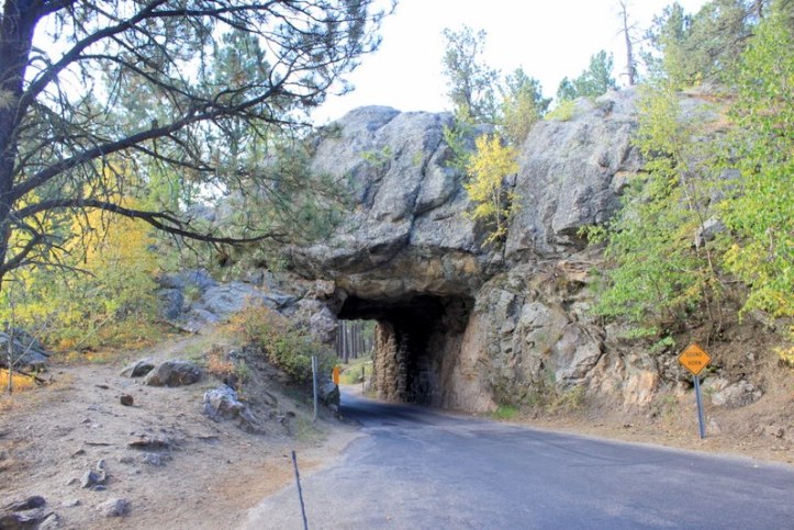
Iron Mountain Road, US Route 16A, Black Hills National Forest & Custer State Park
Iron Mountain Road, also known as US-16A, is a twisting, turning road in the Black Hills of South Dakota. The road ranks amongst America’s Top Ten scenic byways, and driving the Iron Mountain Road is a life-changing experience.
This 17-mile long road, with its continuously looping curves, three pigtail bridges, and three narrow granite tunnels, is considered to be an engineering marvel. The road passes through the Black Hills National Forest and its breathtaking scenery. The many curves force motorists to slow down and take in the abundant wildlife sightings including deer, coyotes, and chipmunks. The highlight of the road is the view of Mount Rushmore in the distance through the third granite tunnel.
Ketki Sharangpani, Dotted Globe
Texas
The River Road, FM-170 and FM-118 to Big Bend National Park
The best back road in Texas is without a doubt FM 170, commonly dubbed “The River Road.” This stretch of state highway cuts through Big Bend Ranch State Park in West Texasand hugs the Rio Grande (hence the name). Every local we talked to insisted this is the most beautiful drive in Texas, and I’m inclined to believe them. If you’re a hiker, there are plenty of impressive desert hikes in the State Park all along the highway. There are no shops or gas stations here so stock up before you set out. And don’t forget your camera, it’s seriously beautiful.
Erin Mushaway, Sol Salute
Utah
UT Route 12
Highway 12 in Utah is one of the most scenic highways in America. It was designated an ‘All American Road’ in 2002. The route is 122 miles long and has a National Parks at each end, Bryce Canyon and Capitol Reef. Along this stretch of road there are state parks, landmarks, hiking trails and pulloffs to allow you to enjoy the unique landscape. The drive along the scenic byway is memorable with sections of the road going through two red rock arches, over a narrow stretch atop slickrock called the Hogback with a steep dropoff to the canyons below on either side, and through one of the world’s highest alpine forests. Utah’s Scenic Byway 12 is a road you won’t forget!
Jamie, Photo Jeepers
Looking for more Utah content? Click here

Washington State
Strait of Juan de Fuca Scenic Byway, WA Route 112
Washington State Route 112, also called the Strait of Juan de Fuca Scenic Byway, is one of the few must-take side routes while on the Olympic National Park Loop road. The 70-mile road plays hide and seek with the Washington coastline from Port Angeles in the east while leading you to the northwestern-most point of the contiguous United States – Cape Flattery. While on one side of this meandering road, you can see the snow-capped mountains of Canada across the strait which is adorned with numerous seas-tacks, on the other side you can see the evergreen hillocks of Olympic Range. Eventually you get to Neah Bay where you enter the Makah Reservation Area (privately owned by Makah Community still) leading you to a trail, to witness an unforgettable sunrise at Cape Flattery!
Vaisakhi Mishra, Just Words
Wyoming
US Route 191, Yellowstone National Park
(Ed: As with Colorado, winter road closures in Yellowstone National Park prevent me from being able to create a proper map of this road trip)
Highway 191 in Wyoming starts just past the West Yellowstone Entrance to Yellowstone National Park. It must be one of the more scenic roads in the United States.
Along the way, you are likely to see bison, elk, coyotes, and maybe a bear or two. If you are really lucky, you’ll spot wolves (I have!). The road continues through Grand Teton National Park where views of the mountains almost make you forget to look for abundant wildlife. Through Jackson Hole and onto Pinedale, 191 follows the Snake River, Cache Creek, and the Hoback River. It dives under wildlife crossings where the largest migration of pronghorn travel back and forth each year.
All the way to Flaming Gorge National Recreation Area on the Utah border, Highway 191 passes through wild country, ranches, and abundant wildlife – it’s a real peak into the Mountain West.
Melynda Harrison, Yellowstone Trips

Hard to imagine, but…. that’s all, folks!
Stay tuned for another installment of this collaboration next year, and if you would like to participate, please contact me!
Thank you Scott. This is a trip across our “Great Country” from the comfort of your home. I am saving this for many more enjoyable hours of traveling in my easy chair. Elaine Machamer
Thank you Elaine! I’m so glad you’re enjoying it! If you have any suggestions you would like to see included on the list, please feel free to let me know!
What a good way to travel when you can’t travel! I thoroughly enjoyed the blog and am looking forward to the next one. Thanks, Scott for putting this together.
Thank you! I’m so glad you enjoyed it, and I will be continuing to either add to it or build similar collaborations in the future!
Thank you Scott and kudos for compiling this list! This list just made me add so many things to my USA places to see list :D. Bookmarking it! (This is so gonna help me while planning some road trips)
Thank you for your kind words! I’m so glad it will be a useful resource for you – that was the primary intent in building the blog!
Thanks for organizing this road trip post. I’m sure I will use this for inspiration on my future travels around the USA. So much more relaxing and interesting to take the back roads instead of the interstate highways.
Susan,
Thank you so much for your participation! I’m grateful for your submissions, and especially for your help in finding other partners!
[…] careers. I was the latter. Upon graduating, I packed my things in boxes and made the trek from South Dakota to begin my career in […]
is it possible to drive backroads from Brattleboro vt to Menomonee falls Wisconsin? I am anxious about driving on expways and interstates would like to take backroads if possible. thanks much
Hi Connie, thank you for reaching out!
If you would please send me an email at scott@takebackroads.com, I am glad to help! I will also reach out to the author for Wisconsin to see what advice they can offer you.
Hi Connie!
I know it’s been a year, but I actually now have a program where I can help you with very specific, detailed road trip planning. Check it out:
https://takebackroads.com/plan-your-road-trip/
[…] order to pull this list together, I built on the initial groundwork laid in my earlier road trip mega-collaboration. In this installment, I delve even deeper into back road options for you to consider: working […]
[…] Convenience is also destroying America’s incredibly dynamic culture. […]
[…] I drive on unpaved roads to reach a trailhead. The seats are very versatile, making it great to roadtrip with. Its fuel economy isn’t too shabby […]
[…] the countdown clock for departure for my 2019 Thanksgiving Mega Road Trip. Find out why I only do back roads. In addition, why am I taking a trip through the American Midwest. Learn more in […]
Great list to use when filling in the states that I have not visited on my bucket list. Seeing nature is much more enjoyable than the usual stops.
Thank you, Geri! It’s been – by far – my most successful post ever, probably for that exact reason! If you hadn’t noticed, there are still a few states that I’m missing – they are listed near the top of the post – if you would like to contribute, please email me: scott@takebackroads.com Thanks!
My family is from Alabama. I moved to Missouri just over 40 years ago. Get in contact when you head for either state and I’ll give you some great info.
Great, thanks so much! Likewise in Pennsylvania, WV, or Ohio!
Absolutely!
[…] year, I collaborated with roughly 40 travel bloggers to put together the first installment of the Great American Road Trip series. That behemoth of a post looked at the best back roads on a state-by-state basis. While […]
[…] Part One – the Best Back Road by State […]
[…] Lastly, for a list of the best back road by state, click HERE. […]
[…] Road Trip Ideas […]
[…] Kentucky Route 80 – Cutting across the southern edge of the state, KY-80 is filled with scenic beauty and plentiful options for exploration […]
[…] What’s the best back road in California? Click HERE […]
[…] The Best Back Road in Each State […]
[…] Roads: Venture off the main highways and onto charming back roads that wind through quaint towns and rural areas. This route offers an intimate encounter with local […]
[…] Road Trips – the best back road by state […]
[…] travelling to dark sky locations. There’s a comprehensive breakdown of some of the best back road adventures you can take in each state – many of which are located in areas with minimal light […]