
Last year, I collaborated with roughly 40 travel bloggers to put together the first installment of the Great American Road Trip series. That behemoth of a post looked at the best back roads on a state-by-state basis. While it’s a very comprehensive look at some of the best road trips in the country, it was also a remarkable amount of work to coordinate and build. I don’t have an exact total on how long it took to put together, but I’m guessing it was at least 100 hours.

This year, I decided to make my life easier. With a full time job selling insurance, it can be a challenge to make that kind of time for Take Back Roads. And yet … I love to write, and to share my images, especially when it’s travel-related material!
The solution to this problem was simple – this year, I’m writing about my own favorite back roads! Since 2016, I’ve driven (or ridden my motorcycle) over 75,000 miles in over 25 states – including some of the most famous roads in America!
So, in the interest of time and for the sake of my sanity, this year’s Great American Road Trip post will be my Top 10 Favorite Back Roads in the country. Like last year, they will be split up by coast – East and West – but with just five entries for each.
What should you pack for a road trip?
Excellent COVID-19 Protection Options to take with you:
Disclosure: This post contains affiliate links. This means that I receive a commission – at no cost to you – if you purchase one of the products I’ve linked to on this page.
My Favorite Back Roads in America
Other than the split East (first five) and West (last five), my favorites are in no particular order:
- Blue Ridge Parkway – NC
- Cherohala Skyway – TN & NC
- The Devil’s Highway – PA Route 66
- Appalachian Highway – NC & VA – US Route 21
- Staunton-Parkersburg Turnpike – WV & VA – US Route 250
- Foothills of the Rocky Mountains – CO – CO Routes 24 & 67
- Veteran’s Memorial Highway – NV – US Route 95
- Mojave to the High Sierras – CA – US Route 395
- Red Rocks Road – AZ – AZ Route 89A
- Pacific Coast Highway – CA – Route 1
If you would like our help planning your road trip, please click here.
Looking for a road trip playlist? Click here.
Want to know more about how to take back roads when you travel? Click here.
Without further ado, let the road trip begin!
The Best Back Roads in America – East Coast Road Trips
Back roads on the East Coast have a well-established history. Some of the original farm roads and forest trails date back to long before the invention of the automobile. With abundant rolling hills, mountains of thick old-growth forests, and bodies of water everywhere, the eastern seaboard has a heritage of twisting scenic routes navigating the length and breadth of the coast.
Growing up and living on this side of the country and traveling the area extensively on family vacations, I’ve explored countless panoramic roads on the East Coast. These five are my favorites.
Blue Ridge Parkway Road Trip – North Carolina & Virginia
If you’ve ever experienced the Blue Ridge Parkway, you know that it defies any attempts at describing its beauty. Spanning nearly 500 miles between the western tip of North Carolina and the northern half of Virginia, the Parkway bisects a number of heavily traveled routes to coastal destinations. It weaves from southwest to northeast through tight twists and broad curves, spanning ridge to ridge along the spine of the Blue Ridge section of the Appalachian mountains… But don’t expect to travel those dreamy curves at a high rate of speed, or you’ll miss out on the entire point of taking the road.
Over the years, I’ve driven short spans on the Blue Ridge Parkway several times. I’ve always been on my way to or from a family vacation, and thus limited to only a very minimal detour. Early in the summer of 2019, I finally was able to drive a much longer stretch. Its reputation for awe-inspiring panoramas is well deserved. Much of the road winds its way quite literally on the ridge of the mountain, almost as if you are driving along the knobby and contorted spine of this ancient range. Like the Pacific Coast Highway, virtually every bend in the road delivers a new vista to behold – expansive wooded peaks roll like lush green waves toward the horizon in every direction.
And if the landscapes alone aren’t enough to entice you to head to the BRP, there are also countless activities along the way to entertain the entire family. From breweries to bicycle tours, museums to murals, and caverns to castles (well, if you call the Biltmore Estate a castle!), as well as a handful of charming mountain communities (make sure to stop in Little Switzerland!), there’s something for everyone to experience on the Blue Ridge Parkway!

Cherohala Skyway – Smoky Mountains Road Trip, Tennessee & North Carolina
Unlike it’s more famous neighbors – the Tail of the Dragon and Blue Ridge Parkway – the Cherohala Skyway lives in virtually anonymity … a “best kept secret” of the Smoky Mountains, if you will. Clocking in at just over 43 miles, the Cherohala Skyway is one of the shortest drives on this list. What it lacks in length, though, it more than makes up for in character.
I will find myself in pretty sparse company in this opinion, but I enjoyed driving the Cherohala Skyway the most out of all the roads in the region – including the Tail of the Dragon – for a number of reasons. Loaded with broad, sweeping panoramic views of the surrounding mountains, the Skyway features a diverse and open terrain. I found the Dragon to be too tight and claustrophobic – not to mention too crowded – to experience the full range of capabilities that your vehicle has to offer.

The Skyway, however, boasts a captivating and challenging blend of sharp, tight turns and wide sweeping bends that allow drivers to row back and forth between all of the gears their transmission has to offer. Unlike the Dragon, which is tightly hemmed in by trees and rocks on both sides, the Skyway is also mostly open, offering drivers and passengers incredible scenery to enjoy while testing the limits of their vehicle (and driving skills!). And, best of all, the Cherohala Skyway boasts a fraction of the crowds you’ll find on the Blue Ridge Parkway.
My personal recommendation for the best driving experience in the area:
Start at Tellico Plains, ride the entire length of the Cherohala Skyway through Robbinsville, shoot over to the Fontana Dam Visitor’s Center, then head up to Deals Gap (making sure to stop and take in the cliffs across the bridge just west of the dam) to ride the Tail of the Dragon.
The map of the route will look like this: MAP
The Devil’s Highway – PA State Route 666, Allegheny National Forest Road Trip
At just over 30 miles, PA Route 666 is by far the shortest back road listed here. But don’t be lulled into complacency by the shortened simplicity of this route through the heart of Allegheny National Forest; it packs a twisting and scenic punch, with a couple pleasant surprises tucked in along the way.

Nestled into the woods as a shortcut of sorts between two very historic US Highways – Route 62 and Route 6 – PA Route 666 (map) is definitely a wilderness route. It runs mostly east to west through the dense Pennsylvania woods between two small towns in one of the more sparsely populated areas of the state. There are very few intrusions of man-made structures along the way, making it a peaceful naturalist paradise.
The inclusion of Route 666 might be at least partially influenced by my own nostalgia for the road, which I discovered on my first trip to the Finger Lakes region in Western New York…. but that’s not to say it doesn’t deserve its spot on this list. The road is a highly enjoyable blend of tight curves and long sweeping bends through the forest. Because nearly half of the road runs immediately adjacent to the broad waters of Tionesta Creek, it doesn’t feel closed in by trees or claustrophobic – in fact, several stretches offer very pleasant panoramas as you make your way along.
One of the best features of the route is also one of its best-kept secrets. Tucked into the woods behind a gravel lot, the Tall Oaks Store is an adorable little family-run gift shop where my wife and I first discovered Corinthian Bells wind chimes – easily the best sounding chimes I’ve ever heard or owned. But I digress – Tall Oaks Store is an absolute Americana-style gem, and makes the entire trip worthwhile.
And with plenty of awesome things nearby to see and do, a trip to the wilderness of Northern Pennsylvania should definitely be on your bucket list!
Appalachian Road Trip – US Route 21, NC & VA
This one stands out in my mind at least partially for emotional reasons – it was a big part of the first long distance back road trip that we took as a family. We’ve driven at least parts of the route several times since then, including on the cross country road trip in the Porsche, as well as on family trips down to the beach in the Carolinas, Georgia, and Florida.
Route 21 has been such a central part of my travel history because it runs parallel to one of the central routes heading south from my homes in Pennsylvania and Ohio – Interstate 77. Though I-77 is actually not a terrible route to drive, as far as interstates go, it’s still nowhere near as enjoyable to drive as its counterpart. As is the case with most back roads, US-21 cuts a far more scenic path between Cleveland and Columbia, SC than I-77, and it cuts straight through the heart of countless mountain and farming towns along the way. (Technically, Hunting Island Lighthouse, about 25 miles south of Columbia, is the southern terminus of US-21)
Being a key part of so many of my east coast road trips over the past decade or so, US-21 is a foundational part of some of my most formative grown up travel “memories.” Its simple beauty, its pastoral peacefulness, and its crisply aired mountain towns cemented my belief in the richness and value in back roads travel. It might not have the epic scenery of some of the other routes on this list, but it’s full of interesting things to see and do from end to end.
West Virginia Mountains – US Route 250, WV & VA
Curiously, US Route 250 in West Virginia and western Virginia book-ended my recent back roads travel experiences: the initial ride that prompted me to start this website, and my most recent long distance road trip from Pittsburgh to Florida and back. Way back in 2013, my wife and I left Pittsburgh on a drizzling and chilly Friday afternoon in May. We started out trying to navigate the highway, but in those conditions it was miserable. We made our way off the highway and continued heading south across the mountains of West Virginia.
Things began to look up as we weaved our way into the wilderness. The precipitation had quit, and the clouds were breaking up. We were finally able to focus our attention on our surroundings a bit more – and thank goodness we were! The plants and trees all around us recently awoke from their winter slumber, and the road itself twists and winds its way up and down the rolling foothills of the Appalachian Mountains.
At one point, we wound our way uphill out of a particularly thick stretch of forest, and as the road curved around the peak of the hill, it opened up to a truly jaw-dropping panorama. West Virginia’s famous rolling terrain stretched out for miles before us, seemingly challenging us to try to root out its deepest secret beauty.
It was not the last of these challenging vistas: US-250 is loaded with them. As we continued to make our way towards Virginia, bobbing and weaving our way from densely wooded mountaintops to valley-floor farmland, our mood lifted with each new rise in the road. On our descent from the mountains down into the farm country of western Virginia, we stopped in the adorable village of Monterey for a pot of hot coffee and some hearty home cooking at High’s Restaurant. We’ve been there several times since then, and it never fails to raise our spirits!
US-250 traverses one final range of mountains before dropping you into the Shenandoah Valley – where you’ll find no shortage of things to see and do. Make sure to plan some time here, and especially to hang out in the adorable college town of Staunton.
The Best Back Roads in America – West Coast Road Trips
Back roads on the West Coast don’t have the long history that their East Coast counterparts have. What they lack in heritage, though, they more than make up for in scenery. Back roads on the West Coast feature some of the most dramatic terrain I’ve ever seen. Every turn promises the possibility of a new breath-taking panorama, and scenic vistas are both abundant and free.
I traveled to the West Coast for the first time when I was a teenager; however, I didn’t start truly exploring the area in depth until the Jeep Trip in the Desert in 2016. Since then, though, we’ve driven and camped extensively across California, Nevada, Arizona, Utah, and more. Here are my five favorite back roads on the West Coast.
Rocky Mountains Road Trip – US Route 24 & CO Route 67, Colorado Springs to Denver
What was supposed to be a road trip from Pittsburgh to Colorado for a family wedding got cut short. We planned to drive out, explore the area for a couple days, attend the wedding, and drive home. Then my wife’s work situation changed, and we were suddenly limited to a mere three day weekend. Instead of driving 3,000 miles in 10 days, we found ourselves flying into Denver late on Thursday night. We rented a car and drove to our AirBNB in Colorado Springs.
Though most of our time was spent with family, our flight home on Sunday wasn’t until early evening, so we spent the afternoon taking the very long way back to the airport. The drive out of Colorado Springs and up into the mountains starts on US Route 24, passing the beautiful Garden of the Gods on the outskirts of town.
Garden of the Gods Park in Colorado Springs
From there, Route 24 meanders leisurely up into the foothills of the Rockies, eventually reaching Pikes Peak. Unfortunately, the winding drive to the summit of Pikes Peak would’ve added nearly an hour in each direction, so we had to take a rain-check… but the rest of the drive helped us to quickly forget our time-related woes!
After passing through the adorable mountain town of Woodland Park and picking up CO-67, the trip really hit its stride. A couple miles worth of crisp fresh air in a surprisingly open spruce forest cleansed our lungs and our minds, and whet our appetite for the mountain peaks visible in the distance. We were mesmerized by the vibrant red of the clay and how it contrasted wonderfully with the floral greens and brilliant blue sky. We were enchanted by the narrowing crags of rock that edged closer and closer, tightening our perspective but deepening our excitement as the road twisted us onward to each new discovery.
The trip took a rapturous turn when we found that it traces the path of several bodies of water: the meager trickle of West and Horse Creeks, followed by the frigid rush of the South Platte River. Itinerary be damned, we had to stop and dunk our toes in, and dunk we did. In spite of visiting in late July, the melt-water fed river was indeed quite nippy, providing a wonderfully refreshing bite around our dance-swollen ankles.
Fly-fishing in the South Platte River
After drinking in as much of the scenery as we could during our riverside respite, we had to bid the Rockies a sad farewell and complete our journey. Google Maps always manages to slap at least one dirt road into every one of our back road adventures, and this trip was no exception. A short but jarring drive on the red dirt road section of CO-67 knocked us out of our reverie and back into reality, just in time to begin our descent to the depressing normalcy of Denver suburbia.
With the mountains in sadly in our rear view mirror, we returned our rental car, boarded our flight, and vowed that we would return soon to explore the area in much greater depth.
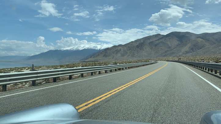
Veteran’s Memorial Highway – US Route 95, Nevada – Desert Road Trip
I suspect that, unless you live relatively close to it, that very few folks have heard of US Route 95 in Nevada. It’s quite special, though, as it is one of a only a handful of roads in the country that runs the entire way from Canada to Mexico. Because the route runs through some of the most desolate and isolated areas in the country, it’s never been replaced by an Interstate Highway.
So how did such an isolated stretch of road – one of the only places I’ve ever been where I was legitimately concerned about running out of gas – make it on this list? As the only way to drive from Reno to Las Vegas, I experienced it for the first time on our cross country camping adventure, and immediately fell in love.
Once you drive Route 95 through the heart of western Nevada, you will quickly understand why it made the list. The desert is a harsh, alluring mistress. You won’t be able to take your eyes off her. She’s full of danger, but that’s part of the attraction, too – and very few people are willing to endure the risk involved. You’ll have this beauty almost completely to yourself.
It’s like driving across the flat bottom of a wide, ornately decorated ceramic bowl: the sandy valley floor is rimmed on all sides by the jagged peaks of scrub-covered and occasionally snowy mountains.
The driving itself is generally pretty easy – mostly long, flat, and straight road stretches out in front of you for miles. This would automatically disqualify most routes from making this list, but it actually is beneficial for Route 95: You’re actually able to glance around as you drive and take in the surrounding beauty.
Route 95 doesn’t pass through many towns along the way – be sure to get gas when you do! – but the few you’ll see are pretty incredible. Visit the Ordnance Museum in Hawthorne, home of America’s largest ammunition depot. Learn about central Nevada’s mining history at one of the museums in Tonopah. And for a town with less than 300 people in it, Goldfield has a surprising amount of things to see and do: the International Car Forest, the Art Car Park, the Radio Museum, and several unique shops like the Hidden Treasure Trading Post. Heck, there is even an old-fashioned saloon!
Don’t forget to grab a beer and a bite to eat at the Sourdough Saloon, and before you know it, you’ll be speeding into the suburban sprawl surrounding Las Vegas.
Mojave Desert to the Eastern Sierras – US Route 395, California Road Trip
US Route 395 in eastern California is a photographic folk legend. A quick Instagram search reveals nearly 75,000 photos tagged “#395” – and related posts add even more to the count – and with good reason. Originating near the San Bernardino Valley in Victorville, US-395 knifes it’s way nearly straight north up through the mountainous eastern side of California, finally terminating at the Canadian border.
The route runs parallel to the Sierra Nevada Mountain range and dissects some of the most diverse landscapes in the country. At the southern end of the route, the eastern side is lined with the most imposing desert landscapes in the country. One could easily visit several famous desert parks, including Joshua Tree National Park, the Mojave Desert, and Death Valley. To the west lays Sequoia National Forest & National Park, followed by Kings Canyon.
As you continue further north, the landscape morphs from stark desert beauty into lush alpine forest. After passing Inyo National Forest, you’ll enter into the valley between the Sierras and White Mountains. There’s the world-renowned skiing at Mammoth and June Lakes, followed by the world famous Yosemite National Park a bit further to the west. The eastern side of this section of Route 395 is lined with countless hidden hot springs where locals love to soak away their stress. Another 100 or so mountain-lined miles and a short jaunt into Nevada, and you’ll reach the Lake Tahoe and Reno areas.
Though Route 395 continues further north through northern California, Oregon, and Washington state, the stretch from Victorville to Tahoe is easily its most famous and most fabulous. Though the road itself is fairly straight and easy to drive, its simplicity allows you to focus more of your energy absorbing the intensity of your surroundings. A road trip on 395 requires a bit of planning, though: a traveler could easily spend a week or more exploring the numerous natural attractions along the way and still not see everything!
Red Rocks Road Trip (Oak Creek Canyon) – AZ Route 89A, Flagstaff to Sedona Arizona
In a weird kind of way, the beauty AZ Route 89A ended up being a pleasant surprise. Though we both visited Flagstaff before, neither of us ventured south towards Sedona. We had no idea about the head-turning scenery that awaited us.
The first five miles or so heading south from Flagstaff are a generic straight stretch through thick evergreen woods. You round a nondescript rocky bend in the road and suddenly start down a precipitous drop, tautly navigating the absurdly curvy switchbacks. Distracting cavernous vistas overwhelm your view out all the windows as you wind your way back and forth down into a heavily wooded canyon.
The canyon was cut by the rushing spring-fed waters of Oak Creek. The sides of the road are lined with bustling tent-camping sites and abundant trailheads. As you continue further south through the canyon, you pass by the small but scenic Slide Rock State Park. After another mile or so, the canyon walls taper down and the trees thin out to reveal the first of the burnt orange rock formations Sedona is famous for.
Before long, 89A cuts straight across the “downtown” shopping district in Sedona. Though the town has only 10,000 inhabitants, it is a vibrant and famous art community. 89A is densely lined on both sides with New Age shops, spas, organic product stores and numerous art galleries. Heavy tourist traffic generally clogs the road through town, and topless pink Jeep tours seem to sprout straight out of the asphalt.
Once you veer west out of town, you’ll soon pass the loop of road that drops you down to visit Red Rock State Park. To my eternal shame, I had never even heard of the park before our cross country camping adventure. It quickly locked itself into my memory, though, and helped to further solidify the Flagstaff area as one of my favorite places in the country. Though we didn’t pay the entrance fee to actually go into the park, we found several places along the outskirts from which it is easily visible… and taking a dip in the frigid waters of Oak Creek ended up being one of my favorite memories from that trip.
From Red Rock Canyon, 89A continues further south and west through Coconino National Forest on its way towards the mountain town of Cottonwood. Though the drive from Flagstaff through Sedona is a relatively short one – roughly an hour to drive about 40 miles – it’s surprisingly dynamic and filled with addicting natural beauty.
Pacific Coast Highway – Big Sur Road Trip – Route 1
As should always be the case, I’ve saved the best of the list for the very end. I wish I were a more poetic person, though, as I am quite certain my written words will not do the Pacific Coast Highway justice.
If you follow this website – or the Facebook and Instagram pages – with any regularity, you know that I’ve driven more than my share of remarkable back roads over the years. From the European Alps to the Rocky Mountains, from the depths of the Costa Rican rain forest to the thick piney woods of the Blue Ridge Parkway, I’ve spent much of the past decade collecting a plethora of photos and memories navigating the back roads of the western Hemisphere.
Yet none can match the beauty of the Pacific Coast Highway. None. It sits unquestionably at the top of my list of back road driving experiences, unchallenged by any of the contenders. It is, quite possibly, a conglomeration of all the best features you can possibly dream up for a back road.
The scenery along the Pacific Coast Highway is jaw-droppingly, description-defyingly, cliche-inspiringly gorgeous. The landscape is a lumpy rolling quilt of earthen tones, patched together between large sections of hay-colored grassland and brick-red clay. This quilt drops over often precipitous edges down into the foaming aquamarine waves of the Pacific Ocean. The sunsets are brilliant explosions of color, setting the sky on fire as the sun settles into the horizon, then quickly cooling things off again into deep blues and purples as it disappears off into the distance.
The road itself presents a dynamic range of driving experiences: twisting and winding its way along the jagged edge of coastline, weaving in one cove and back out toward the next, repeatedly swooping up and down from hill to hill like a carefree young bird that’s finally learned how to fly. There are abundant scenic overlooks for you to pull over and do your damnedest to try to photograph your surroundings. And heck, when we were there, the road wasn’t even that crowded!
Yet the sum of these descriptions still don’t completely paint the picture of why this road is so remarkable. It’s almost the sheer idea that a place so perfectly composed could even exist, combined with the genuine “bucket list experience” feel to the place, that lends the Pacific Coast Highway it’s uniquely powerful appeal.
You’ll just have to drive it in order to fully understand.

Like the videos in this post?
Subscribe to my YouTube page to see everything I post!
Sounds like a good trip. Wish I had been on it,, even though I don’t really like roughing it.. Thanks for the travel comments.
Thanks! I’ve been extremely fortunate to have been on several excellent trips in the past four years! I can’t wait to see what new adventures the future brings! Hope you are well, and love to you and the family!
[…] led me to develop the collaboration idea you see here. Since it would be impossible to take every back road in America, I recruited help: travel bloggers from all across the country. I reached out with a simple […]
[…] US Route 250 – A zig-zagging route that runs diagonally across West Virginia, Route 250 cuts you through the heart of some of the wildest places in the state […]
[…] My Favorite Road Trips […]
[…] delays, you are going to be absolutely stunned by the natural beauty of what is easily one of the greatest back roads in the country! I digress. Bioluminescence in the Pacific waters requires impact or strong […]
[…] along one of our absolute favorite scenic drives in the Bay Area, eventually dropping you onto the Pacific Coast Highway in Jenner. You’ll wind your way through towering redwood trees as you follow the course of […]
[…] Looking for a list of my personal favorite back roads? Click here […]